Don’t always trust alltrails.com…
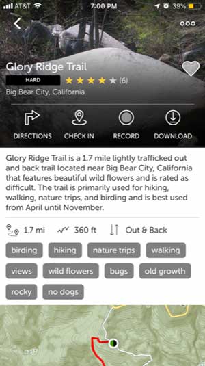
Trail Name: Glory Ridge Trail
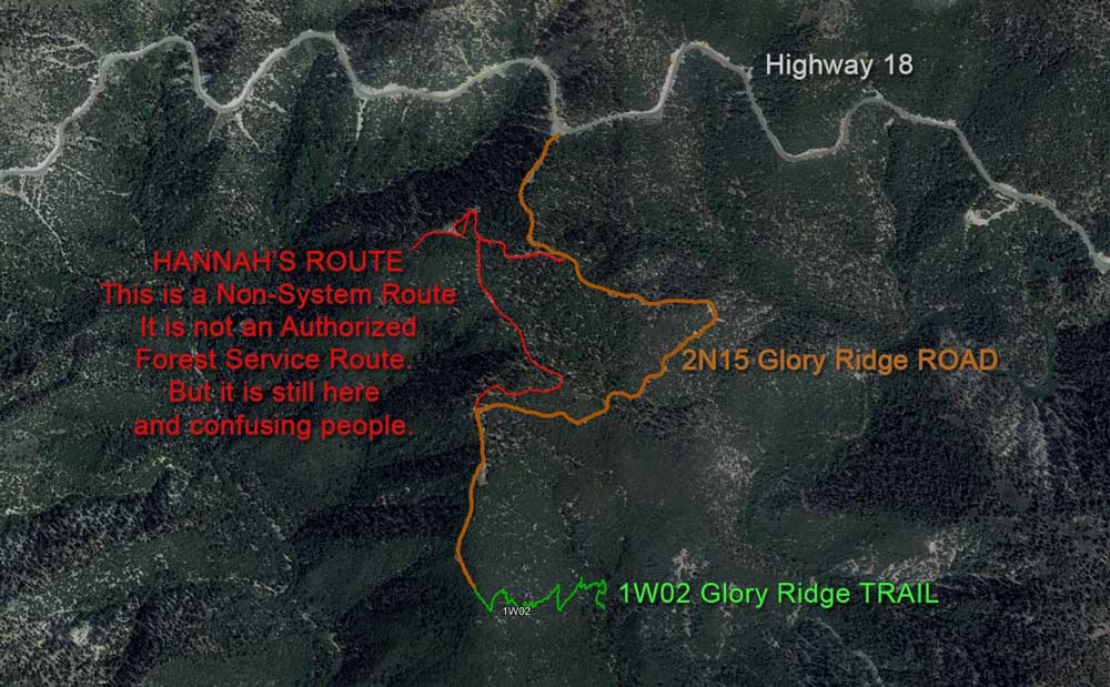
Forest Service Designation: 2N15 (See picture below. Route described is actually a non-system route. Glory Ridge Trail is 1W02).
Total Distance: 1.7 miles (with an additional 0.5 including the walk from the parking area to the trailhead).
Overview: A short hike with a slight downhill on the way out that can be difficult at times on the way back.
Difficulty: Moderate
Activities: This is primarily a trail for hiking; it would likely be difficult to use an off-road vehicle or to bring a horse on this trail as there are very deep divots from erosion along about half of it.
Trail Type: Out and back
Possible Loops / Variations: Although the trail is designed as an out and back trail, at the end of the trail one can follow Glory Ridge Road back to the trailhead which would add another mile and a half or so.
Trailhead and Parking: The trailhead is located at the 2N15 turnout off of Highway 18, 7.5 miles outside of the center of Big Bear Lake.
On the first Sunday in December with about four inches of snowfall still on the ground from the week before, I decided to hike along the Glory Ridge Trail. The temperature was in the mid-30s and it was perfect for taking an afternoon hike. This was the first time I had hiked along this trail and was excited because it was a new goal of mine to discover new hiking trails in the Big Bear area. Upon arriving at the trailhead, I didn’t have any expectations about what I would find along the trail but was happy to be enjoying my Sunday afternoon outside.
Oops. Hannah used a smartphone trail app that had incorrect information.
In order to get to the trailhead, we had to walk about a quarter of a mile down the steep 2N15 fire road which was covered in about an inch of slippery compacted snow and ice. Another group of people that were there to enjoy the sledding hills in the area brought along their pet dog who was very excited and slipped down the hill and slid right into us! Once we got to the trailhead, we thought that we were the first ones to use this trail since the snowfall; not long after we embarked, we realized that this was actually a high traffic area for the wildlife in the area.
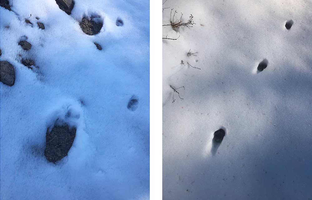
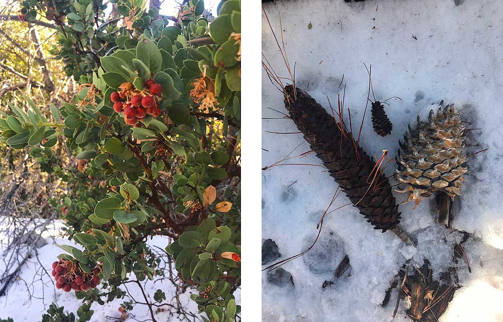
It was incredibly interesting to take the time to identify different types of animal tracks along the hike and to try to make sense of what the animals who made the tracks were doing when they were walking (or running) along the trail. We identified what we believe to be rabbit tracks, deer tracks, coyote tracks, bobcat tracks, and even one set of bear tracks that followed along the trail for a short time before turning off the left side and going down a hill into the woods below.
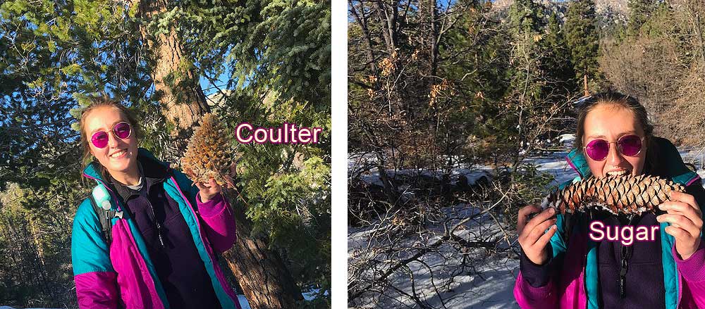
Not only was there abundant evidence of the fauna that frequented this area of the woods, but abundant species of plant life as well. Alongside the Jeffery and the Ponderosa pines that we often see near the hiking trails that we use every day at High Trails, there were also countless Coulter pines and Sugar pines that we don’t get to see so frequently in our corner of the San Bernardino National Forest. In order to find a patch of Coulter pines near High Trails, you have to hike out quite a ways and therefore have to be deliberate about choosing a day when the weather is fair and the students are energetic.
It was also intriguing to notice the difference in some of the plant species that I see regularly around the High Trails Camp Edwards site. For instance, manzanita bushes are along most of the Edwards hiking trails and during this time of the year I do not often see red berries on the ends of the branches, often if there are any berries on the branches in December they are brown and dried up. Along the Glory Ridge Trail, however, most of the manzanita bushes had round, deep red berries on them, perhaps because of the amount of sunlight they receive and the warmer temperatures that come with that at the side of the slope where they sit. I would be interested to come back along this trail in the springtime and see the diversity of the plants that bloom when the snow melts.
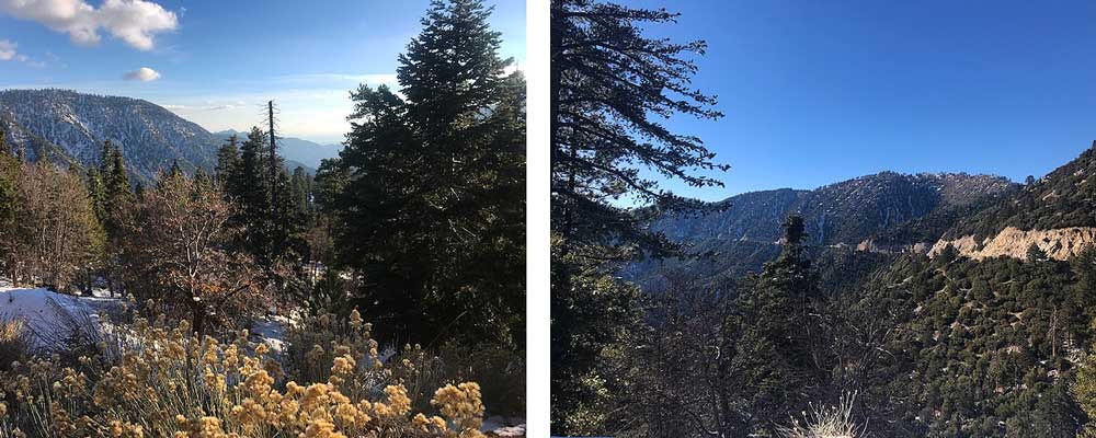
Once we arrived at the end of the trail we were greeted by a cluster of Sugar pines, a few Coulter pines, and some Ponderosas that overlook deep into the valley, from here it looks like the ridges of the mountains go on forever.
You know you are at the end of the trail when it meets back up with Glory Ridge Road. After enjoying the view for some time, we decided to head back along the trail rather than opt to take the longer route along the road. Initially, I was so excited and distracted by the animal tracks and the flora that I barely noticed the slight decline I was walking down; I certainly noticed the incline on the hike back to the trailhead. It took us about 40 minutes to walk to the overlook with stopping to take pictures and analyze the scenery, but the way back took closer to an hour without much conversation and stopping only a few times for brief water breaks.
Upon arriving back at the car, we were feeling accomplished and energized from our hike, it was the perfect length and difficulty for me on a beautiful snowy Sunday. I encourage anyone who is interested in animal tracking and/or admiring the diversity of local plants to give the Glory Ridge Trail a try.
At High Trails Outdoor Science School, we literally force our instructors to write about elementary outdoor education, teaching outside, learning outside, our dirty classroom (the forest…gosh), environmental science, outdoor science, and all other tree hugging student and kid loving things that keep us engaged, passionate, driven, loving our job, digging our life, and spreading the word to anyone whose attention we can hold for long enough to actually make it through reading this entire sentence. Whew…. www.dirtyclassroom.com
Comments are closed.