 The day is September 11th, 2014. I am standing face to face with a weathered and worn wooden sign on the top of a mountain in the middle of Maine. The sign reads, in big, white letters, “Katahdin”. Below this are more words and numbers on the sign. The words that stand out to me are “Springer Mountain,” and the number next to it, “2,185 miles.” Six months earlier to the day, I had set out to hike the Appalachian Trail from Georgia to Maine, and after following approximately 165,000 white blazes, I had arrived at the northern terminus, Mt. Katahdin, on a cold, rainy, and windy day. I had navigated myself through over 2,000 miles of trail.
Believe it or not, I hiked the entire Appalachian Trail without having to use a compass – the trail was that well marked!
On any other long hike, especially something like the Pacific Crest Trail or the Continental Divide Trail, a compass would be an absolute essential! Here’s a bit about these long hiking trails and then a bit more about how to use a compass on them to avoid getting lost.
 What is the Appalachian Trail?
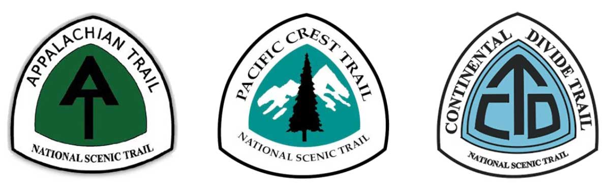
The Appalachian Trail is a 2,185 mile footpath stretching from Georgia to Maine, on the Eastern United States, and it follows the Appalachian Mountain Range. The Appalachian Trail is a National Scenic Trail. That’s a serious trail!
What is a National Scenic Trail?
According to the National Trail Systems Act that was signed into law on October 2, 1968, National Scenic Trails, “will be extended trails so located as to provide for maximum outdoor recreation potential and for the conservation and enjoyment of nationally significant scenic, historic, natural, and cultural qualities of the area through which such trails may pass.” 1 The first two National Scenic Trails were the Appalachian National Scenic Trail and the Pacific Crest National Scenic Trail. Since the conception of these two trails as National Scenic Trails, nine more trails have been deemed National Scenic Trails by congress. Including the Continental Divide National Scenic Trail.
 What is Through Hiking?
Completing any of these trails from end to end, while creating a continuous footpath, in one calendar year, is called Through Hiking. That’s a lot of hiking! If a single person completes the Appalachian Trail, the Pacific Crest Trail, and the Continental Divide Trail as through hikes, then they are known as Triple Crown hikers.
Each of these trails represents a unique challenge in terms of navigation. The Appalachian Trail is the easiest to navigate. Trees are marked with a 6 inch by 2 inch painted rectangle called a “blaze”, the trail is well maintained and traveled on often creating an easily followed trail.
The Pacific Crest Trail is also easily navigated because of its well maintained and often traveled footpath, however, the Pacific Crest Trail isn’t as well marked and has trail intersections that can be confusing for an unprepared hiker. Also, the Pacific Crest Trail can lead to elevations up to 13,000ft at Forester Pass in Kings Canyon National Park, where snow from the previous winter can cover the trail and make navigation even more difficult.
Unlike the Appalachian Trail and the Pacific Crest Trail, which are trails with 100 percent official routes, the Continental Divide trail is only about 70 percent complete and offers many Alternate Routes or road walking opportunities, making it the hardest of the three trails to navigate.
Can a person hike that far without getting lost?
Absolutely! In our modern day, advancements in technology have brought us a long way. The entirety of each of these trails have been mapped out and are available on GPS. However, as students learn in our Outdoor Survival Hike, a GPS is a non-essential item to carry when you are in the wilderness. This is because a GPS is unreliable – it relies on battery for power and on satellites for accuracy, both of which can disappear when you need it the most 2.
If not GPS, then what?
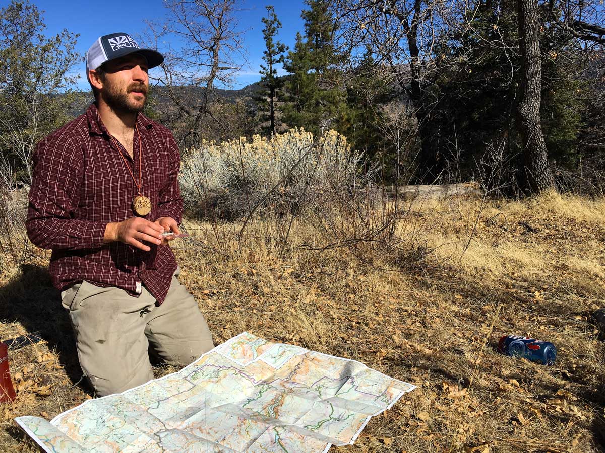
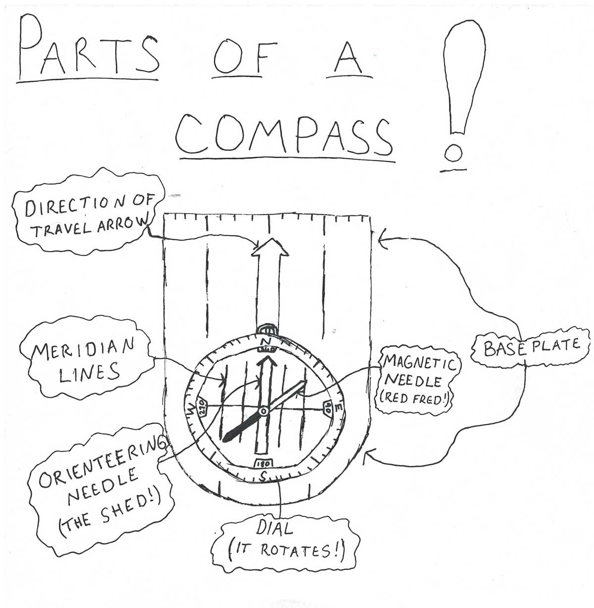
Enter, old faithful, Map and Compass! The accuracy of using a map and compass relies on the skills acquired by the user and the refinement of these skills. Learning how to navigate using a map and compass can be a fun and rewarding process, especially for the modern day adventurer! The features on a topographic map allow you to align the geography you experience in the wilderness with the features on your map. This allows you to orient yourself to your environment.
 How can a map and compass be used?
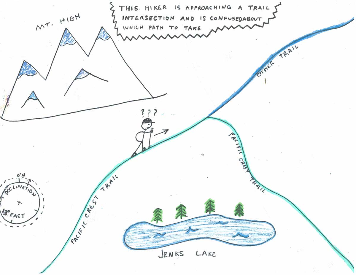
Imagine you are on the Pacific Crest Trail and you have come to a trail crossing but are unsure of which path to take. First, you must adjust your compass for declination. Declination is the difference in the direction that the magnetic needle is pointing versus the direction of true north. Your magnetic needle on your compass is always pointing to magnetic north, and all maps are made in relation to true north, which is the geographic northern most point on earth. A good topographic map will show you the declination between true north and magnetic north.
Once you have done this, you can orient your map and compass to point towards true north. Take a look at the map and apply your surroundings to what you see on the map. Doing this can help you decide which trail is the Pacific Crest Trail and which trail is the one that will not lead you to where you want to go. Also, once you have oriented your map and have found your location on a map or a point on the map you are interested in, you can find bearings and apply them to the field.
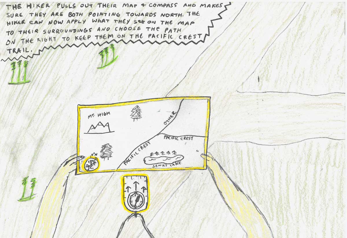 A bearing is the direction of one point in relation to another point or in relation to your compass. You can find bearings in the field and transfer them to your map as well as being able to find bearings on your map and transfer them to the field. In order to effectively use a map and compass you must constantly be in tuned with your surroundings as well as your map.
Learning these skills takes time and effort and refining these skills takes practice, but if you put in the time then perhaps you can navigate yourself on a National Scenic Trail some day!
At High Trails Outdoor Science School, we literally force our instructors to write about elementary outdoor education, teaching outside, learning outside, our dirty classroom (the forest…gosh), environmental science, outdoor science, and all other tree hugging student and kid loving things that keep us engaged, passionate, driven, loving our job, digging our life, and spreading the word to anyone whose attention we can hold for long enough to actually make it through reading this entire sentence. Whew…. www.dirtyclassroom.com
Comments are closed.